Trail information for Calif. Section B

The overview of Calif. Section B
California Section B - 100 miles
Start - Hwy 79, mile 109.5 3,030 ft [near Warner Springs]
End - Hwy Interstate 10, mile 209.5 1,335 ft [near Cabazon]
Highest point at 9,048
Check for information for this section about trails and updates:
- PCTA.org
- US Forest Service at the San Jacinto Ranger Station at +1(909) 382-2921
- Pacific Crest National Scenic Trail USDA - US FOREST SERVICE
- San Jacinto Trail Report [trail information, water, & weather]
- Jon makes this report does this by his labor and time is volunteered, the San Jacinto Trail Report completely depends on small private donations to cover operating cost. You can visit the Donate page if you have found that his report was useful. Just at the end of the day report.
- https://www.sanjacjon.com
- Pacific Crest Trail Water Report:
Exit/Entry points in this section of Trail-Heads
- North Bound PCT you can leave the trail at:
- Most of the exit drops you to one of the Hwys
- The highways are narrow curvy mountain road, often with little or no shoulder to walk on. It can be dangerous, especially during weekends with traffic. Hitch a ride, connect someone for a pick up, or Trail Angel !!]
- Check the section for paid ride
- Hwy 74 - Highway 74, Pine to Palms Highway - mi 151.9 - 4906 ft {18 miles south of Idyllwild} go west one mile to Paradise Valley Cafe for water & food
- Water only when open!! 1(951-659-3663)
- CedarSprTr - Cedar Spring Trail Junction - mi 162.6 - 6765 ft paved road from Hwy 74
- FobesRanchTr - Fobes Ranch Trail Junction - mi 166.5 - 6002 ft from a dirt road to/from Hwy 74 and crossing a river bed (most of the time dry)
- Fobes Spring 2mi
- Fobes Trail 4mi
- Pacific Crest Trail 6 mi
- SpitlerTr - Spitler Peak Trail junction - mi 168.6 - 7047 ft down the Apple Canyon Road to Hwy. 74 at Hurkey Creek Park 7.6 Miles
- Spitler Peak Trailhead mile 4.7 good spot to get a trail angel by phone {Grumpy does pick up here}- check next note
- [Limited ATT. Phone Service - call on the way down]
- {Spitler to Idyllwild Alternate Routes A & B by trail - click the red button below}
- the Route B from Hurkey Creek Park to Idyllwild - (has been closed in the past due to fire closures) now open to foot and Bike travel
- South Ridge Trail (3E08) turn off from TqtzPkTr - Tahquitz Peak Trail - mi 178 - 8616 ft
- some years can be very dangerous and deadly from the icy conditions (2022 one death)
- to Idyllwild or from Idyllwild - just to the west down to Forest Road 5S11
- then Travel to the pave road called Saunders Mdw. Rd. at 5618 ft and follow it north
- and down to the Hwy. 243 turn right to town
- SaddleJct - Saddle Junction, Devils Slide Trail to Idyllwild - mi 179.4 - 8139 ft to Humber Park, 2.6 miles W of PCT - mi 179.4 - 6552 ft {Once you reach Humber Park
- [No ATT Phone Service at Humber Park - call on the way down],
- it's another 2.6 mi. road-walk to center of the town Idyllwild
- at PO0179 - Idyllwild Post Office, Idyllwild -5397 ft}
- StrawberryJct - Strawberry Junction, Deer Springs Trail to Suicide Rock, Idyllwild - mi 183.4 - 8069 ft {The 4 mile long Deer Springs Trail (4 miles N of Saddle Jc)] is another way to reach Idyllwild
- and you end up on Hwy 243 just 7/10th of a mile NW of the State Park Campground & center of Idyllwild]
- RD0191 - Black Mountain Road, unpaved - mi 190.7 - 7689 ft {seven miles to Hwy 243 (north to Banning or south to Idyllwlid}
- [Limited ATT Phone Service at the Hwy - call on the way down to the hwy]
- ByPass was and still is (if this route is to much for you due to the snow or other weather conditions):
- following the Black Mountain Road to Hwy 243 {eight miles} and
- then go north to Interstate 10 where you can connect back to the PCT at 209.5 mi
- This highway is a narrow curvy mountain road, often with little or no shoulder to walk on.
- It can be dangerous, especially during weekends with traffic. Hitch a ride or Trail Angel !!]
- Can not do - [Some hikers roadwalk the 8.2 miles of Hwy 243 from Idyllwild to reach Black Mountain Rd.}
- this was to connect back to the PCT at the RD0191 to leave the mountain
- The start of Section C at 209.5 mi
- Interstate 10 - to the West about four miles to Cabazon by Railroad Ave south of Interstate 10 209.5 mi
- Morongo Casino Resort six miles west 1(951) 849-3080 www.morongocasinoresort.com
- Desert Hills Outlets seven miles west 1(951) 849-5018 www.premiumoutlets.com
- including many food places and Food Court, and yes Starbucks and many other fav
- check out for section C & D fire closure areas
- WHITEWATER PRESERVE 218.5 mi +1 (760) 325-7222
- Currently open in the day time - 8am-5pm
- Restrooms and water open during operation hours
- Overnight camping open give a call.
- https://wildlandsconservancy.org/preserves/whitewater
- whitewaterpreserve@wildlandsconservancy.org
- North on the trail Permits for preserve camping, backcountry trip parking, and afterhours hiking are available at the preserve ranger station during open hours, in person or by phone.
- Now open again
- after being the Feb. 14, 2019 flooding the area out and the road -
- For daytime open and Camping open for 2022 & 2023
- ?? 2024 call
- TRAIL CONDITIONS
- The Canyon View Loop Trail remains PARTIALLY CLOSED due to damage from Tropical Storm Hilary on 8/20/23. This is the trail section that crosses the riverbed north of the parking lot, and leads to the Pacific Crest Trail and Red Dome. Damage includes multiple steep cliff faces, and the riverbed trail is now a boulder and debris field. Additionally, there is no stone staircase or footbridge across the river. Much of the Canyon View Loop can still be enjoyed as an out-and-back hike beginning from the bottom of the parking lot. Visit the Ranger Station for more information and trail maps.
- Great place to stay
- The Wildlands Conservancy
- 9160 Whitewater Canyon Road
- Whitewater, Ca 92282
South Bound PCT you just reverse the order
Four Alternate Routes From Paradise Valley to Idyllwild
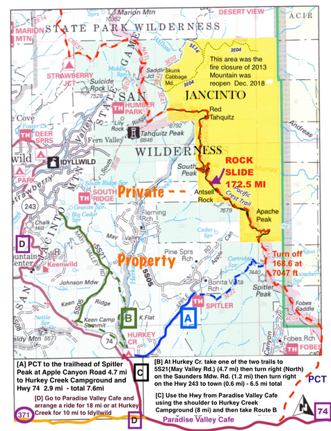
Alternate Routes {A} Spitler to Hurkey Creek Park: {B} Hurkey Creek Park to Idyllwild {C} Walk along the Hwy 74 to join Route B: {D} Pick up a ride to Idyllwild or off the Mountain
Spitler to Idyllwild Alternate Route: Two parts of separate Alternate Routes {A & B} This route has been use for alternate route to Idyllwild for heavy snow, and other bad ice conditions, then for Fire Closures {now open} and Rock Slide {now gone}.
Spitler to Idyllwild Alternate Route Map, Directions, Parks

Spitler to Idyllwild Alternate Route
ROUTE A - Spitler to Hwy 243 at Hurkey Creek Park
ROUTE A - Spitler to Hwy 243 at Hurkey Creek Park
The detour starts after Spitler Peak to the Hwy 74 by trail to Apple Can. Road {paved road.} Route A then to Idyllwild Route B Now Open again! TOTAL = 30.7 miles from the crossing of Hwy 74
ROUTE A - Spitler to Hwy 243 at Hurkey Creek Park
ROUTE A - Spitler to Hwy 243 at Hurkey Creek Park
ROUTE A - Spitler to Hwy 243 at Hurkey Creek Park
- Route A blue color lines & dashes on the map
- Frist part of this alternate route is used to escape the weather &/or trail conditions or the Rock Slide
- Spitler Peak trail junction - mi 168.6 - 7047 ft start of Alternate Route mile 0.0
- SpitlerPeakTH - Spitler Peak trailhead Apple Canyon Road mile 4.7
- Hurkey Creek Park 4436 ft Mile 7.6 This par
- Route A blue color lines & dashes on the map
- Frist part of this alternate route is used to escape the weather &/or trail conditions or the Rock Slide
- Spitler Peak trail junction - mi 168.6 - 7047 ft start of Alternate Route mile 0.0
- SpitlerPeakTH - Spitler Peak trailhead Apple Canyon Road mile 4.7
- Hurkey Creek Park 4436 ft Mile 7.6 This part can be reached by Hwy 74 from leaving or starting
- Now only the HWYs. 74 & 243 are open most of the time except during heavy rain storms because this roads can flood!
- Must use the Hwy 74 and Hwy 243 to get to Idyllwild {by vehicle for safety} if not using the trail and roads of the May Valley Area
ROUTE B - Hurkey Creek Park to Idyllwild
ROUTE A - Spitler to Hwy 243 at Hurkey Creek Park
Route B green color lines & dashes on the map
- to hike at a lower elevation to reach Idyllwild other than fining a ride
- Off Road Bicycle Riding are using this route again 2023
- the bike races are not back, yet.
- At Hurkey Creek Campground hike to north part look for the gates mile 7.6
- [one by the creek {straight north leaving the creek} gate of
Route B green color lines & dashes on the map
- to hike at a lower elevation to reach Idyllwild other than fining a ride
- Off Road Bicycle Riding are using this route again 2023
- the bike races are not back, yet.
- At Hurkey Creek Campground hike to north part look for the gates mile 7.6
- [one by the creek {straight north leaving the creek} gate of coyote run section], or
- [the back left towards the Hwy. {follows along the Hwy. than take road 5S05 East}]
- The goal is to change over to the May Valley Rd. 5S21 North mile 9.7
- Travel to the pave road called Saunders Mdw. Rd. and follow it north and down to the Hwy. 243 mile 12.3 (T - intersection)
- Turn right which is east to town mile 13.5 {6.5 miles from the campground to Idyllwild} 14.1 miles Total [All of this 14.1 miles].

Overview
Review: PCT 16.6 miles plus Alternate Route Spitler Trail 14.1 miles TOTAL = 30.7 miles

Two Campgrounds & Store
Two Campgrounds & Store
Hurkey Creek Park Cost $30 per site up to six personsis a campground with showers that is a part of the Riverside County Park system.
Lake Hemet Park Campsites $45Only ten (10) lake view cabins are available. Reserve your cabin today by calling at
+1(951) 659-2680
Lake Hemet Market
Sun-Thur: 8am-5pm Fri & Sat 8am-7pm
Just south of H
Hurkey Creek Park Cost $30 per site up to six personsis a campground with showers that is a part of the Riverside County Park system.
Lake Hemet Park Campsites $45Only ten (10) lake view cabins are available. Reserve your cabin today by calling at
+1(951) 659-2680
Lake Hemet Market
Sun-Thur: 8am-5pm Fri & Sat 8am-7pm
Just south of Hurkey Creek Park is Lake Hemet where:Classic shows such as Airwolf and Bonanza also had episodes filmed there.
If at looks Dangerous change trail route or get a ride!!
Some hikers bypass the PCT by traveling the Hwy. Route {74 to 243}.
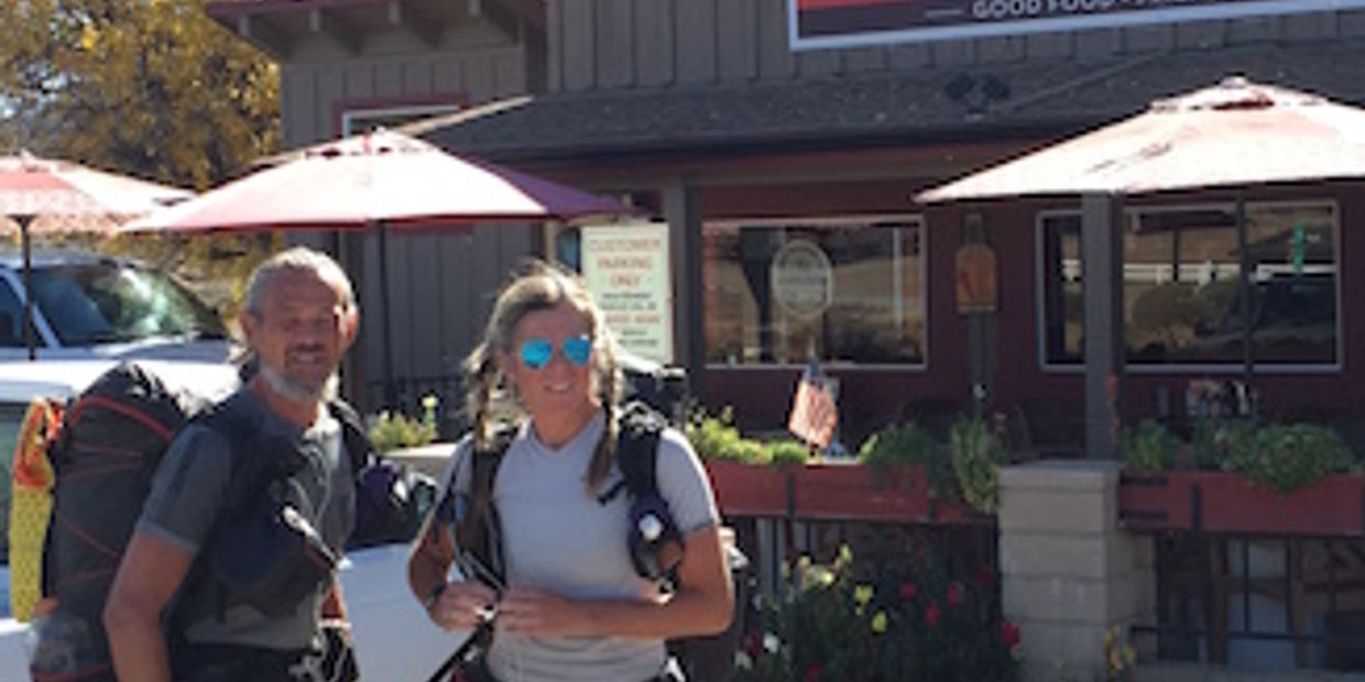
Before then go to the Paradise Valley Cafe - Take a load off, take care of the needs restroom, food, drink, rest and talk to others and get information.
A spot to take time to check your process and look for the plans ahead.
Check which route is best for you at this time.
If the PCT route is to dangerous for you this is a good time for an Alternate Route and/or transportation to go around the problem or just leave the PCT.
Paradise Valley Cafe
+1(951) 659-3663
at hwy.74 151.9 mi mark go west one mile:
While making a choice - enjoy a wonderful meal in the mountains (some say it is the best ever). Located at the intersection of the 74 and 371 highways in Mountain Center, CA. Great friendly patio is a wonderful place to spend the morning or afternoon.
They will help by offering you the best food in a great environment.
Also, they can get equipment from Nomad Venture (like mircospikes & ice axe).
Help you get Trail Angels.
Good place to use this web looking under Places to Stay to make reservation and know you have a place to stay
- (for Fri. & Sat do fill up and same for campgrounds).
Open daily:
Mon-Tue 8am - 3pm
Wed-Sat 8am - 8pm
Sun 8am - 7pm
(They have some phone numbers for Trail Angels.)
Can get rides to Idyllwild here!
Water inside only during hours open, 1 mile W of PCT.
Using the Hwy. 74 route traveling north has a shoulder until you reach Hurkey Creek is OK. But, at this point use the trails and roads listed from the map starting at Hurkey Creek Campground. OR, pick up a ride to Idyllwild [by Hwy 74 to Hwy 243] for this part of the trip.
There is no place to walk this route {Hwy 74 & Hwy 243} without being on the road with the traffic .
Planning for a ride - here are some pay transportation for bypassing part of the trail.
Back to the home page under Transportation - use button below.
There are Trail Angles for local trips and just a thumb with a pack gets friendly local residents - money not required but most will except tips or gas money. Talk to people for other possibilities, the business [gothook, oops - FarOut].
The best way off the mountain for hitching a ride is at Paradise Corner. Going east on highway 74 less than 20 miles to highway 111 is Palm Desert. then you can get any type of transportation.
This is the heaviest travel tour to the greatest resource of transportation in a 15 mile radius from that point.
THE MAP OF THE TOWN & LOCAL MAP

THE Paths We Travel - Idyllwild
TO FIND THE TRAIL HEADS BACK TO THE PCT.
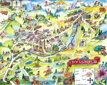
THE COLORFUL MAP
Some of the buildings and businesses have changed.
