Trail History 2013-2021

Since 2013 the Section B has Trail Closures: Fires, Rock Slide, Forest Closure [do to Fire Danger] and off the trail with Roads closures from weather: Until 2021
A Closer Look at the area of the 168.6 TO 178 with the PCT & Alternate Routes Seasons 2013-21
Fire Closures that effected the trail:
- Fire History 2013-21
- 2020 Snow Creek Fire
Valentine's Day Storm 2/14/19 Rain Damage to the roads 2019-2020 seasons.
Last is the History about the Rock Slide on PCT 172 mi- 2019 to June 2021
Trail Information-Alternate Routes/History of use

A Closer Look at the area of the 168.6 TO 178 with the PCT & Alternate Routes
The picture above is a map for the Cranston Fire Closure for the season of 2019.
The West Boundary is along the PCT from Spilter Peak Trailhead Junction to the Tahquitz Valley/Tahquitz Peak Lookout tower South Trail {about 168.6 to 178 mi.}. The Southern Boundary was at the Spitter Peak Junction to the Spitler TrailHead down the Apple Canyon Road to Hwy 74.
2018 Season was the first season since 2014 that this Alternate was open from the PCT to Idyllwild..
(This route was opened up from the Mountain Fire 2013 for the 2018 Season.) [2019 Season only reopen from Hurkey Creek to the PCT]
This junction of PCT at Spitler Peak is know as the Spitler Peak to Idyllwild Alternate with two parts which I call Routes A and B. This is a 14.1 mile bypass for the 10.8 miles of the PCT. Which was an important Bypass for bad trail conditions because of weather, snow and ice (the next 10.8 and beyond is at higher elevation starting at 7047 ft.
- Route A travels West downward for 7.6 miles to Hurkey Creek County Campgroundand Hwy 74 at 4436 ft.
- At 4.7 miles is the Spitler Peak Trail Head on Apple Canyon Road at 4905 ft
- some people call from here for a ride or ordered one in advance
- a place where some people get rides to Idyllwild.
- At 4.7 miles is the Spitler Peak Trail Head on Apple Canyon Road at 4905 ft
- Route B travels from Hurkey Creek to Idyllwild at 5350 ft.
- (This part does not go over 5650 ft. in elevation to finish the 14.1 trip.
- By trails and a Forest service roads (May Valley Road & Bonita Vista Road)
- then ending a paved Road in Idyllwild called Saunders Meadow Road North to the Highway 243 East to Town.)
- (This part does not go over 5650 ft. in elevation to finish the 14.1 trip.
In the section of Trail you can find a more details on this Alternate Route: [or push the button below]
Route for the Spitler Peak to Hurkey Creek Park to Idyllwild was done on a map Called HalfMile:
- *{This is a great route for bad winter trail conditions (when under deep snow and ice) from Spitler Peak area to a lower elevation to pass thru this section of trail to Idyllwild and from Paradise Valley Corner by road to Hurkey Creek Park then the roads and trails.}
- Spitler to Idyllwild Alternate Route Map was with Halfmile maps not available any more since March 2019. See under trails section for direction for details of this route. - go to the end and push the red button "PCT Maps" - Halfmile's www.pctmap.net/maps/
- This map has been updated first time since 2015 PCT maps - Halfmile's are now done by National Geographic Map. Now handy new map booklet [without half mile marks and milage].
- ]https://shop.pcta.org/https-shop-pcta-org-publications-trail-mapsthat is between Spitler Peak to Tahquitz}
A Closer Look at the area with the of Seasons 2013-2021
This closure map from was made for 2018 Cranston Fire
But helps to show the effect for this area from 2014 to Dec. 15, 2018
The PCT Trail from 168.6 to 178 - 10.8 mile Bypass of the PCT
Spitler to Idyllwild Alternate Route
Showing the PCT that was finally repaired eight miles left (of the 10.8 mi) of the 2013 Mountain Fire plus the new area of closure area of the 2018 Cranston Fire until Aug. 01, 2019.
But the Traill was open up to Fobes 2017 and Spitler 2018 junctions.
The Seasons:
Season 2014 to 2017 The PCT was closed down at Hwy 74 to open up to after repairs to the trail up to Fobes trailhead (in 2017). This map area of the high area and Spitler to Idyllwild was closed.
2018 Season The trail between Fobes to Spilter was reopened.
The May Valley was the Part B of the Spitler to Idyllwild Alternate Route from Hurkey Creek Campground to Idyllwild and was reopened for the Year July 15, 2018.
Many PCT hikers used this trail vs looking for a ride.
Until the July 25, 2018 when the Cranston fire burned over that area up to the Pct above that area.
The South Bound had to get a ride from Idyllwild to paradise (151 mi and hwy 74).
Since the Eight miles of the PCT almost repaired before the 2018 fire they were able to finish the total repair plus the areas of the current 2018 fire. It was reopen in Dec. 2018.
2019 Season had a big winter that was to much for many hikers and they came down Spitler Trail Head and where taking rides to Idyllwild.
There was many of the roads washed out in this area because of the Feb. 14, 2019 storm of nine inches with a total of 17+ inches for the month and 37+ inches for the year: that limited the different ways off the mountain from three to one.
2020 Season the roads were where still being repaired and not all open.
Now new is the CODVID-19 were closing many things were being closed down.
The Trail through our area was since open.
Many others did not want to do the Rock Fall came down at the Spitler Trail Head.
2021 Season still with the CODVID-19 with more places were open.
But, the new Snow Creek Fire had the only trail out to the North at PCT 191 mi 206 mi.
The US Forest Service opened the trail only and not the area the Fire Closure on Apr. 3, 2021.
The Rock Slide still there until 6/14/21.
The May Valley area was and so all other Trails and Alternate Routes where open.
Later in the Season of 2021 with are the fires closing down trails, campgrounds, roads, and Parks especially for South Bound Hikes for our area. I do not have how much the fires effect the North Bound hikers.
A Closer Look at the area with the of Seasons beyond 2021
Season of 2024-2025 (Jul. 2024 to Jun. 2025) I am the old way.
Feb. and Mar. both with a total of 9 plus inches of moisture makes this season one of the ten driest year.
11.47 inches up to May (no data - the website gone)
[normal up to this time is 24 inches - normal year is 26 plus]
[based on past on the old July 1 to June 30].
[Oct. to Sept was started by congress a few years so they can have summer off]
- the lowest is (9.60" 2001-2002 out of 26.65 avg. since 1926-1930.
- Winter season with is no normal year but a dry and warm plus windy.
- February and the most of California is affected by this lack of storms, all the way to Lake Tahoe.
Even thunderstorms developing and did in the desert big time May 6.
NOTE: THE PAST 2024::::::::
Was just below normal in moisture and lacking the snow level.
moisture a little low than normal - the high wildness has some problems of ice check
2022-23 YEAR WAS THE BIGGEST SNOW PACK IN THE HISTORY OF CALIFORNIA::::
- [over 500 inches in Mammoth Mountain Ski Area and as of end of June 2023 over 200 inches and skiing into Aug 6,2023]. some areas did not melt to the ground in the very high area and limited the bike riding to three weeks.
- In Section B area of has higher elevation and of heavy snow pack of year [2023] with major weather storms {past six feet or more}
- Many (most) PCT hikers were leaving the trail at (and before) 151.9 mile at Paradise Valley Cafe.
- We (San Jacinto Mountains and Big Bear area) where at the edge of this historic year
2022 season problems where heat and lack of water [one person did die in Anza area].
There has been trail problems and closure from 2013 [Fire Closures from two] to the beginning of 2021 other than normal winter time weather conditions includes;
- fires closures areas, fire dangerous weather, rock slides, down trees, storm washouts of trail & road.
Fire Closures: The effects to the trail
Fire History 2013-2021
Fire Closures: Section B has had Four fire closures in the past 2013, 2018, 2020 & 2021 (2020 fire was closed for the month of March 2021. Now the trails & roads in those Areas are all open, until 2020 bad year for fires in Calif. and this Jan. Two new burn areas in Section B with created one New Closures. Was reopened to hike again as of Apr. 3, 2021 for the Snow Fire closure {to be opened March or April 2022}. The 2021 Bonita fire was only closed during the fire.
2021 BONITA FIRE Jan 15, 2021 was successfully held at about 715 acres
- May Valley Road and western section of Bonita Vista Road
- A snow storm in Feb. 2021 put it out
- Fire out and now Open for Hiking
2020 SNOW FIRE Sep 17, 2020 burned over 6,000 acres full containment Nov. 16, 2020
- Closure of the PCT {16 miles} at Black Mountain Road Forest Road 4S01 mi 191 Until Oct. 2021
- to paved Falls Creek mi 206 to Oct. 8, 2021 near Interstate 10
- Now revisited and lifted so it is Open for Hiking the PCT trail but No Camping Apr. 3, 2021
2018 Cranston Fire Started Wed. July 25, 2018 just before noon Location:
- Now Open Aug. 1, 2019
- off Highway 74 at the Strawberry Creek east of Hemet move straight to Idyllwild and closure of Idyllwild area and then Apple Canyon, Mountain Center, and Garner Valley took place until Sunday July 29, 2018 {five days later}.
- This created a fire closure area until 07/31/2019 included many forest roads and trails.
- {13,139 acres - at 96% contained seven homes were destroyed - three on the road I live on and four in the Mountain Center area.}
- The May Valley area where the roads and trails were closed from July 25, 2018 to July 31, 2019
- the route B of the Spitler to Idyllwild Alternate Route - Hurkey Creek Park to idyllwild thru the May Valley Area were opened for the 2018 season
- After the July 2018 Cranston Fire closed during the 2019 Season until July 31, 2019:
- South Ridge Trail (3E08) from the trailhead to Tahquitz Peak
- Forest Road 5S11 (South Ridge Road) to the South Ridge Trailhead
- The three Yellow Post sites along 5S11 [campsites]
2013 Mountain Fire Started July 15, 2013 PCT Trail reopen Dec. 15, 2018
- Now PCT Trail Open
- Reopen in stages:
- The Fobes Ranch Road was reopen for the 2017 Season
- Spitler Peak Junction was open up for the 2018 Season
- Routes A & B of the Spitler to Idyllwild Alternate Route-
- Hurkey Creek Park to idyllwild thru the May Valley Area were opened for the 2018 season
- Routes A & B of the Spitler to Idyllwild Alternate Route-
- Closure Area on Dec. 15, 2018 was reopen to the following:
- The remaining 8-mile section of the Pacific Crest Trail [mi 168.6 to mi 178]
- (closed by the 2013 Mountain Fire) {that is between Spitler Peak to Tahquitz} finished repairs
- [SpitlerTr - Spitler Peak trail junction - mi 168.6 - 7047 ft]
- [Tahquitz Creek - mi 177.2 - 8151 ft.]
- Opened for the 2019 Season.
- The remaining 8-mile section of the Pacific Crest Trail [mi 168.6 to mi 178]
- All areas Trails and Roads were opened for the 2020 Season
NO problem from doing the trail except for the weather {snow pack and ice}, or the Rockslide to dangerous many use the Spitler to Idyllwild Alternate Route.
Many thru-hikers reach the San Jacinto Mountains early in the hiking season when snow and ice still cover parts of the trail.
- Snow often begins on the north side of Apache Peak [mile 169.5] and continues 21 miles through Fuller Ridge.
- If the winter is a strong one and brings snow it would stop many from hiking the higher elevation trail of the PCT.
Spitler to Idyllwild Alternate Route for Section B from the map of last year U S Forest Service or half-mile map had a problem:
- [the trails and roads were closed due to the 2018 Cranston Fire Area Closure] the trails & roads are now open for Fire Closure was lifted.
- So, the last part of the Spitler to Idyllwild Alternate Route - the northern section from the Hurkey Creek Campground County Park to Idyllwild:
- stream trail out to May Valley Road 5S21,
- trail along side of the Hwy 74 to road 5S05
How to cover over this area if not taking the PCT or the Spitler to Idyllwild Alternate:
- [Do not walk the road from Hurkey Creek to Idyllwild]
Travel this distance safely by using a vehicle from Hurkey Creek Campground or Paradise Valley [151.9 mi] to Idyllwild [179 mi] by hitching a ride or Trail Angel.
Note - The trail takes 30 miles plus the exit trail while by vehicle it is less than 20 miles from the Hwy 74 crossing to Idyllwild.


Snow Creek Fire 2020
2020 Snow Fire Closure is Lifted & Trail Reopened April 3, 2021 - Revisited and ByPass Options
The Route was Reopened on Apr. 3, 2021 - for hiking only!!
2020 SNOW FIRE Sep 17, 2020 burned over 6,000 acres
- full containment Nov. 16, 2020
- Closure of the PCT
- at Black Mountain Road Forest Road 4S01 mi 191
- to paved Falls Creek mi 206 to near Interstate 10
- there has been talk about reevaluating when to open up that will be after March 2021
- Was revisited and lifted Apr 3, 2021 and the Closure was Lifted for Hiking only, No Camping for the 16 miles.
- This Fire Closure Area should be lifted Oct. 2021.
- Revisiting how to deal with the Closure can be use in other ways to ByPass the snow area and harsh weather.
There are three ways to deal with this 15 mile {closure} bypass of the Trail. Now a new way {number four} is the Palm Springs Arial Tramway ReOpen {has been closed for their normal yearly maintenance opening back Oct. 11} or so.
- Take a look as ByPasses:
- or
Two, arrange a vehicle transportation at Idyllwild which be may a day or two while having place to stay and eat (by vehicle 36 miles).
- or
Three, work getting transportation at Paradise Valley Cafe towards the desert for interstate 10. From there to go West back to the Trail.
- It is the best place to hitch a ride in the whole mountain area.
- or
Four, the Palm Springs Aerial [has ReOpen but limited with advance tickets for round trip] and then get local transpiration to Highway 10 West to the PCT crossing. This has one to two things to get everything to work.
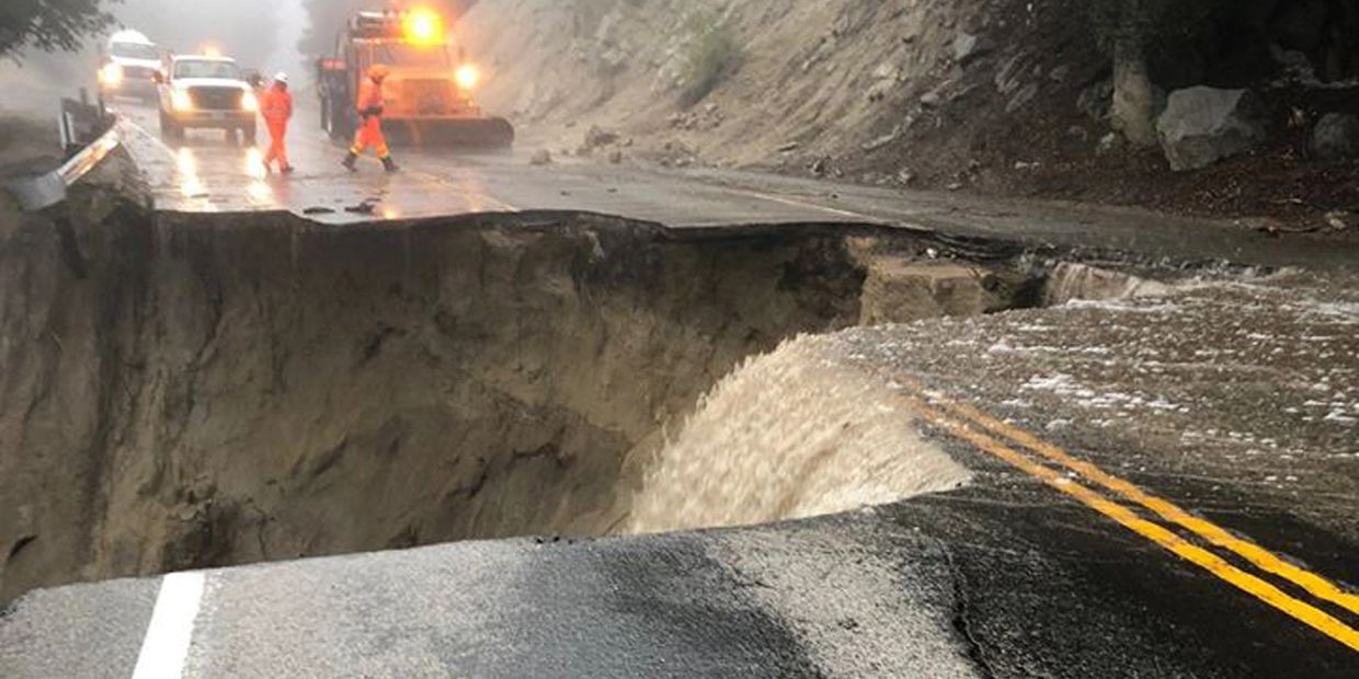
Valentine's Day Storm 2/14/19 Rain Damage
Valentine Storm most damage was the Roads
Valentine's Day Storm: {All Roads open as of Nov. 01, 2019} (All Roads finished repair work Jan 2021)
- After Feb. 14 a day of 8 plus inches of rain with snow on the ground from the last storm [17 plus inches for Feb]
Roads were Effect by: {Feb. 14, 2019} Rainstorm Closure Hwy 74 West and Hwy 243 North
- Traveling between Hurkey Creek Park and Idyllwild on the Hwy 74 and Hwy 243 area were limited travel for a few days.
- The only way to Idyllwild was from the south from Palm Desert by Hwy 74 or from Temecula by Interstate 15 to Hwy 79 East to Hwy 371 through Anza to Hwy 74 North.
Then repairs were started:
Two ways to Idyllwild were closed down until repairs and rebuilding the roads From:
- North of Idyllwild/Pine Cove on Hwy 243 to Interstate 10 Banning closed down
- was later the road was open up at Pine Cove to Lake Fulmor
- for nine months the Banning side was not opened for any travel
- as of Nov. 1, 2019 the Hwy was fully opens
- Hwy 74 West at Mountain Center to Hemet was closed down at first for major work to be done: Then Limited escort started:
- after Easter: Escort 5-8am & 6pm-Midnight,
- then the beginning of June Escort 5-8am & 6pm-Midnight M-F and 4am-Midnight S-Sn
- On 09/03/19 was be opened 24/7 but Escorted [roadway repaired but not finish repaired and had up to a half hour wait] at times the total of an hour with travel
- As of Oct 3, 2019 is complete open (but some road work can being worked on with controlled flagging during the daytime {one lane traffic} 6am-6pm M-F until Oct 2020 up to 30 min delay.
- Still some work on weekday was going on in Feb. 2021 Now all finished!!
The weather winter season 2018-2019 start with a wet feed of air by tropical wet warm moisture (El Nino Year). 2018-2019 year was 37 inches for the year.
Feb. had a 8 inch plus day on Feb. 14 with a total of 17 inches recorded [but two days did not record of about two inch which would have made it the wettest Feb. around 19 inches] {July to June is 26 inches average}.
This year 2020-2021 is a major drought, having less than half the moisture, but most of the moisture is in low level snow. One inch of moisture can make ten inches of very light snow. from July to the end of March the total 11.40 and the year avg. is 26.46 inches. Currently the fourth driest year. {2017-2018 was 11.43)