Welcome - The State & Forest Service Wilderness - This year

ALL TRAILS ARE OPEN IN SECTION B --But the weather -- BUT --Check Section C Ahead!!
Grumpy's last day for this season driving is May 21, 2026, until next mid March 2027.
In the higher elevations and bad weather - go hike in groups!!!!
Postal Office only open 12 to 1 pm Saturday for outgoing only!!!!
Palm Springs a record for March over the whole U.S. At 110 degrees.
NO CURRENT BIG PROBLEMS FOR WILDERNESS CLOSURE IN SECTION B
THE WEATHER HAS BEEN SOMETHING DIFFERENT:
Since Aug. 20 a large number of topic storms with two of them with down pour over half inch in less than 15 minutes!! Over 3 inches!
This winter has been dry 2025-2026 season:
Jan. 2.5 inches (4.5 normal)
Feb. normal at 2.8 inched (4.6 Normal)
March nothing zero (4.6 normal)
WITH TEMPERATURE
We HAVE BEEN averaging up to 23 degrees plus degrees over normal to records of 87 then 90 records in Idyllwild.
April fool day a few days cool down.
WARNING:::::
BUT WE ARE MOVING UP TO 85 DEGREES A SUMMER TIME HEAT IN EIGHT DAYS OF HEATING AT ELEVATION OF 5,200 FEET.
(Big Bear at 75, Palm Springs in the 90's (up to 100’s).
April fools day time form a weak storm (0.25 to 1 or so) for rain and a drop to normal temperature and high will be snow like Big Bear level and San Jacinto peak areas!!
Total to date is about 14 inches for an average of 26.5 inches ending June 30.
______________________________
________________________________
Season of 2024-2025 (Jul. 2024 to Jun. 2025) I am the old way.
Feb. and Mar. both with a total of 9 plus inches of moisture makes this season one of the ten driest year.
11.47 inches up to May (no data - the website gone)
[normal up to this time is 24 inches - normal year is 26 plus]
[based on past on the old July 1 to June 30].
[Oct. to Sept was started by congress a few years so they can have summer off]
- the lowest is (9.60" 2001-2002 out of 26.65 avg. since 1926-1930.
- Winter season with is no normal year but a dry and warm plus windy.
Check Section C. Ahead!!
Check the PCT Association Trail Closure and Problems beyond SECTION BEYOND SECTION B::
- ALERT SECTION C WAS BAD FOR 2024 and still is for 2025::
- Whitewater and Mission Creek in Section C - the most impacts to travel are in the upper portion of North Fork Mission Creek (mile 235 -239) This maybe years - with no money to fix it!!
- Managed by San Bernardino National Forest in Sand To Snow National Monument [This is close Hwy 38 and Onyx Peak]
- Storm damage thanks to Aug. 2023 Tropical Storm Hilary that effect Southern Calif. and more Desert - many roads washed out and even Death Valley
- TO GO AROUND THE PROBLEM be only by road: To go around this area start at Interstate 10 to the Big Bear Area or Onyx off of Hwy 38 RAINBOW LN at mi 253.1 or Pipes Road leave straight at the first bend or go down the road until across the PCT. (By Bus check the PCT Ass. under area closure on So. Calif.)
- THE CROSS COUNTRY ROUTE: [Dangerous to do]
People are now taking a cross country route: This is crossing or cutting across of a U-shape of the bend of the stream bed!!
- Leave the trail at 236.4 (near a campsite and elevation just above 6,000 ft.).
- Go North:
- You should be returning back to the trail at 245.1 (at elevation just above 8,000 ft. and with a view of a Peak).
- Distance around 2 miles without the gain of elevation.
Do not do this alone!!!
(mark your trail so you can retrace your way back- if needed)
YouTube:
4. PCT 2024 NoBo, Mission creek - Big Bear
mile 226 - 266 ridge walk bypass
This is about 236 mi just before a camping site straight north up a ridge.
www.youtube.com/@callofadventure6733
He has his whole trip to Canada on y-tube
_____________________________________________
---Best answer is getting Transportation: ---
- Hiking::: is coming off the PCT at Interstate 10
- - go up Black Mountain Road at Hwy 243 for eight miles PC 190.7 then take to the Interstate 10 at mi 209.5.
- THIS is only nine miles from town and go by a Trail Angel to that location
- - go up Black Mountain Road at Hwy 243 for eight miles PC 190.7 then take to the Interstate 10 at mi 209.5.
- OR Hitching::::::
- Do not Hitch below the Mountain area it is illegal in California (the law enforcers do not enforce that law it the back areas - but in the back of pick-up trucks the driver will get one - and seat belt one person)
- the beat place to get a hitch is at Hwy 74 and Hwy 371 (Paradise Valley Cafe) going east on Hwy 74 to Hwy 111 Palm Desert about 20+ miles. (it can be minutes with a sign Hwy 111)
- from Idyllwild is a poor way for hours to get a ride to Interstate 10 in Banning. Use a sign "Banning"
Now open again!!!!
- NOTE: WHITEWATER PRESERVE 218.5 mi
+1 (760) 325-7222
- Currently open in the day time - 8am-5pm
- the road finished road repairs Dec. 2023
- Restrooms and water open during operation hours
- Overnight camping open give a call.
- the main trail from PCT the Preserve was gone for 2024 now repaired
- https://wildlandsconservancy.org/preserves/whitewater
- whitewaterpreserve@wildlandsconservancy.org
GO TO PCT ASSOCIAIRION TRAIL CLOSURE FOR MORE DETAILS ABOUT TRANSPORTION OF BUS
Two steps:
- One from Interstate 10 to San Bernardino
- Two to Big Bear

State Park Campground bike/hike Section Big Changes
Just new 04/24/2026 the office is open until 4:00 pm. So you can register for walk in $5 night!’
The sign says it all but a limit of ten people, but still five dollars a night. Second night registration early next morning. Pay before taking a site during their hours as posted - like the sign says! Except the time until 4
JUST NEW AS APRiL - cut back of part works hours!
There is the county park campground half mile away, that has more site available most days.
More information: Web & QR Code

To check what is happening in town
At Pacific Crest Trail Calif. Section B for the Trekkers, we believe that hiking is an adventure that should be accessible to everyone.
May this be one more help to town

THE NEW WAY
THE DIRECT WAY!!
Welcome - Content of the Site -with Transportation and Mayor

WELCOME TO THE IDYLLWILD AREA - SECTION B All Trails and Roads Open
This website is made and update by the owner known as Grumpy.
Special Notes:
- Post Office open on Saturday for pick-up only Noon to One pm
- State Campground only has ten hiker spaces open see about the times must be done at the office ($5 per night).
- Idyllwild Laundry Service - updates under Service Section - [open 8am to 8pm].
Welcome page with information with the next Section Contents:
- Trail & Water Current Conditions & website
- Need Transportation Short & Long (Trail Angels)
- On PCT to - Exit/Entry for Section B
- About This Site
- Paradise Valley Cafe
- Mayor Max
WELCOME TO THE IDYLLWILD AREA - SECTION B - Content Topics
Welcome to Section B. Hope this site can be helpful to you.
Since Mar. 2025, this SITE had some changes because of changed ownership, out of Business & New Business like every year does:
Idyllwild is always changing, going thru the places listed to get better information on each.
A website on Idyllwild - called "Idyllwild, California" www.idyllwildcalifornia.com For an overlook of Idyllwild.
We have lost a few business that I marked TEMPORARY or PERMANENTLY CLOSED.
This website is to help you to your needs.
Use the bars at the top for the section of the list below:
- Home - This Section
- TRAIL & WATER Current Condition & Web sites
- Need Transportation for short trailheads & long trips [some changes]
- About This Site Philosophy and Idyllwild Area
- Start this section by starting at Paradise Valley Cafe
- Words about - MAYOR MAX
- Place to Stay
- they are listed by distance from the center of town to outwards
- IDYLLWILD INN, SILVER PINES LODGE, IDYLLWILD BUNKHOUSE, FIRESIDE INN, & BLUEBIRD COTTAGE INN, these were the main ones open in 2021 serving the PCT hikers during COVID-19.
- Others reopened in 2022, new ownership -> two, went out of business -> three, and one large new. since 2022
- they are listed by distance from the center of town to outwards
- Place to Eat:
- They are listed in groups of same type of business (restaurants, cafe ...etc.)
- Most locations have indoor seating and with outside covered/open
- Some only have window service Inside or outside for only for take-out.
- Most locations can be order in person, or call in and/or web for take out
- days and hours open does change by many factors so {call first}
- Check with some of the trail angles my deliver the food
- They are listed in groups of same type of business (restaurants, cafe ...etc.)
- Stores
- groceries stores, equipment, boots, clothes, and gifts
- Nomad Ventures for Mountain Equipag - gear and etc.
- Services -
- Government
- Government Parks - US Forest, State, & County
- Government: Others
- Fire Department, Library & Post Office
- Business: Shipping
- Miss Sunshine Container & Shipping
- Business: Medical & other:
- Medical Services: Doctor (1), Dentist (2)
- and Pharmacy
- Medical other Massage, Chiropractic, & Acupuncture
- Other Business:
- Hair Care, Laundry & Local Shuttle
- Government
- Trail Info - go to this section for details Including Desciption of Section B
- Exit/Entry Trail, Alternate Route & maps
- with Four Alternate Routes - Because of weather and/or trail condition
- Trail History for 2013 to 2021
- Fire (2013 & 2015 major closures), Rock Fall (the big one -May 2019 to June 2021), and Weather - Roads damaged from a major rainfall (the big one day Feb. 14, 2019 eight plus inches)
- also it effect the roads - closed and/or one-way traffic for repair
- Friendly
- Transportion for off the mountain
Check the end of this section for information about MAYOR Max
- Mayor Max III took office Dec. 10, 2022
TRAIL & WATER Current Condition & Web sites for Sect B -All roads are open! and Trails are Open!
- Trail Problems & Closures: No major at this time::
see the history of 2013-2021 section with new part beyond 2021
There has been trail problems and closure from 2013 [Fire Closures from two] to the beginning of 2021 other than normal winter time weather conditions includes;
- fires closures areas, fire dangerous weather, rock slides, down trees, storm washouts of trail & road.
2022 season problems where heat and lack of water [one person did die in Anza area].
2023 YEAR HAS THE BIGGEST SNOW PACK IN THE HISTORY OF CALIFORNIA
- - many hikers left the mountain for other areas
2024 starting out with limited problems - moisture a little low than normal - the high wildness has some problems of ice check
see the history of 2013-2021 section.
PCT Water Report
Twitter PCT weather updates can be sent by SMS to your phone if you text “follow @pctwx to 40404” even if you don’t have a twitter account. also, can get a print out at the Idyllwild Library.
Part One this will download to a pdf file
"San Jacinto Trail Report"
https://www.sanjacjon.com (Section B Only) Trail reports conditions, and water
"independently run by Jon King"
Jon makes this report does this by his labor and time is volunteered, the San Jacinto Trail Report (completely depends on small private donations to cover operating cost). The Donate page can be found on his report just at the end of the day report. (Zelle, Venmo, and PayPal)
- He started making a trail report (hard copy) bulletins that Jon provided to local rangers to distribute to hikers.
He received a local award "Ernie Maxwell Community Spirit Award 2022" Recipient
- The award is given to recognize, effect on the community. The honor is given to an inidividual or group who represents EMax's spirit of community and volunteerism. Prior awardees took actions that created a spark sufficient to bring others into the fray just as Maxwell did with his activities involving the environment. {go to the story about Jon King for more}
- Idyllwild "Town Crier" Vol. 77 No. 42 Thurs. Oct, 20, 2022}
A GUIDE TO THIS FIRST SECTION

Need Transportation for short trips to/from trailheads or long trips?:
Need Transportation for short trips to/from trailheads or long trips: around problems areas [like closure or trail problem like weather], places to lodge, supplies, food, or medical?
About This Site
Philosophy of This Site.
The Paths We Travel - Idyllwild
Start this section by starting at Paradise Valley Cafe
This is the place to get a great start for Section B.
A place on the Hwy 74 just one mile from the PCT mi. 151.
A place to find rides to/from Idyllwild and other place.
{Before you head for the high wilderness above 8,000 ft.}
Words about - MAYOR MAX [Now Mayor Max III]
As Idyllwild is a non-incorporated town, it has no human mayor. Upon his arrival to Idyllwild, in the past was"Max was accompanied by two deputy mayors: Mikey and Mitzi (Mikey Mighty-Dog Mueller and Mitzi Marie Mueller)." The change a new and younger Max "Max III" with his sister and started His duties on Dec. 10, 2022 after the passing of Max II.
Transportation for short to/from trailheads or long trips
Local persons that are Trail Angels for transportation of the mountain areas, trailheads and town:

There is no service that comes up the mountain (except: Discount Cab Taxi Valley Cab Banning - see below)
Taxi, Bus, Lift, or Uber (the last two will bring people up only or just on vacation for themself).
We have a IDYLLWILD SHUTTLE for local service and twice a week off the mountain routes - go to Service Section for more information (reservation call in).
*IDY Private Driver LES & HOLLY
+1(858) 866-6490
- $ year round
- (see below also long distance)
- Holds up to six persons
- get around in town or get food
- see above for more information
- and Wife Drives, too Holly in her car
- IDYPrivateDriver.com
*Idyllwild Services
+1(951) 392-8460
- $year round Flat rate
- (see below also long distance)
- Rides On & Off Hill
- hold up to four not on Sat.
- www.IdyllwildServices.com
*Grumpy::
+1(951) 500-5954
- Currently on seasons as;
- March 12, 2025 to Memorial
- Hold up to four
- Rides free but, Will take tips!!
*Steven P.
+1(858) 472-5804
- $year round
- email paschallc2@g.mail
- holds four hikers Part Time
- can do longer distance
*Marsha (Marcia)
+1(951) 357-8509
- $year round - mainly local
- (but Airports at time)
- (Tues/Wed/Thur)
ROCHELLE ALDRIDGE
TRAIL ANGELl
+1(760)883-8058
Do Food Delivered in minutes!!!
Monday-Sunday. 6am - 8pm
*Steve's Transportation Service Has Changed to long distance travel only
Another place with angels: idyllwildpcttrailangels@facebook
Next section has a listing of roadways to leave this area:
- Exit/Entry locations to major road travel *2023 year round & 2024 drivers
These names say that they do transportation in this area. I can not verify and not responsible for their actions and services. all charge fees by mile and/or location.
*Grumpy: Since 2017 picking up PCTers, but Limited only to Section B

MAJOR CHANGE for Grump: [MY AD]
Now Grumpy Limited - Seasonal Only.
Trail Angel Service is non fees (free).
Tips are welcome!!
+1(951) 500 - 5954
Text and Voice Only:
Seasonal: {Mid-March up to the Memorial Weekend.}
- First week of April off for part of the week
Main Focus Side Routes from & to Idyllwild:
call for service to or from for reservation*:
To the Road Junction* (hike to/from the PCT):
- Black Mountain Road at Hwy 243 (9mi North) Road 8mi PCT 190.7mi
- Fobes Ranch Road at Hwy 74 (11mi South) Hike Road 6mi Trail & 4mi PCT (166.5 mi)
To the Trailhead* (hike the trail to/from PCT)
- Cedar Springs Trailhead at Morris Ranch Road-(13mi hwy74 - 4mi road) trail 6-8mi PCT(162.6 mi)
- Spilter Peak Junction Trailhead at Apple Canyon Road (Hwy74- 7.5mi) (Road 2.5mi) (Trail 4.7mi) PCT (168.6 mi)
Always call {TEXT} for service to/from for reservation*
- Always the PVC and trail head Hwy 74* at 151mi Crowded at times
- Devil Slide Trailhead at Humber Park* - (179.4 mi
- (limited phone connection at the Park- call at a higher up the trail from coming down) OR Satellite
Limited only in Section B: South at 151 mile Junction of Hwy 74 to Black Mountain Road Junction of the Hwy 243 at North and No dirt roads!!
Local persons that do rides for a price [Fee] Off the Mountain Area:
Steve's Transportation Service
+1(702) 595-2502
- Seating up to six
- Idyllwild to Banning or I-10 Trailhead PCT
- Other long distance locations - such as Airports
- Palm Springs area location
- Acton & Tehcahapi
- Wife drives, at times
IDY Private Diver LES & HOLLY
+1(858) 866-6490
- Holds up to six persons
- Local trailheads
- Airport (LAX-SD-PS-ONY)
- Off the mountain location
- other longer distance like Tehachapi, Acton,
- and other areas near that
- and Wife Drives, too Holly
- IDYPrivateDriver.com
Idyllwild Services
+1(951) 392-8460
- Rides On & Off Hill
- Groceries Delivered to Your Doorstep
- Daylight travel, up to four people, Sun -- Fri
- www.IdyllwildServices.com
*Marsha (Marcia)
+1(951) 357-8509 $
- $year round - mainly local
- (but Airports at time)
- (Tues/Wed/Thur)
Idyllwild Transport
+1(951) 265-6755
- Airports ONT & PSP
Next section has a listing of roadways to leave this area.
These names say that they do transportation in this area. I can not verify and not responsible for their actions and services. all charge fees by mile and/or location.
Off the Mountain Transportation Service:

This is the only company off the mountain say it does service to this area.
Discount Cab Taxi Valley Cab Banning +1(951) 228-6858
- Plan ahead to set a time
- up to seven
- Idylwild to Banning Or I-10 Trailhead PCT
- (around $75 price 2023 price)
Other Ideas to look at to get off the mountain: like Hitching
Other Ideas to look at to get off the mountain: like Hitching
There are Trail Angles for local trips and just a thumb with a pack gets friendly local residents for short & long trips - (money not required but most will except tips or gas money). {Gas is plus $5 a gal.}
- Check around with the Lodging place and business may have other numbers of people to help out
The best way off the mountain for hitching a ride is at Paradise Corner.
- Going east on highway 74 is less than 20 miles to highway 111 is Palm Desert. Then you can get any type of transportation from there.
- [Use a Sign "Hwy 111" there is some signs in the cafe near the inside door on a self]
- This is the heaviest travel route to get the greatest resource of transportation within a 15 mile radius from that point including Palm Springs Airport:
- [it is best and fastest pick up - this is the first part of a two step process:
- (1) to get off the mountain then to HWY 111:
- (2) go where in the desert valley you need to go
- (Hwy 111 is a bus route to Palm Springs)
- {Hitching in Calif is illegal - in the mountain it is over looked)
- If you are coming from Idyllwild add a step 3 and 17 more miles but you should be able to get a Trail Angel to get you to Paradise Corner (Cafe).
The worst way is going north on hwy 243 (that is 30 plus miles to Banning from Idyllwild.)
- Less traffic going that direction and less to offer except Buss service and taxi service
- Long way to go to Palm Springs Airport 25+ miles more and Ontario Airport 40+ miles using Interstate 10
- down there Hitching in Calif is illegal they look for people hitching on the on ramps to the freeway
Talk to people for other possibilities. Like Grumpy.
gothook?? The new name a ownership change to "FarOut" check there too.
About This Site

Philosophy of This Site.
I developed this site to help your trip in this section of the PCT. After a hundred plus miles from the south is my main focus {south to north} with many needs can develop on your challenge or a journey. Resupplying, replacing, and resting is the needed to complete the journey and hopefully without many instances.
The town of Idyllwild has services, stores, places to stay and friendly people who are willing to assist you towards your goal.
Oh, I am Steve. But I go by "GRUMPY" on and off the trail. It's not just a mood it's a lifestyle. I am not an trail angel, but an Angel Assistant and a section B web master. {45 years lived in Idyllwild} see Friendly People Section
Below picture, a look Eastward towards the town of Idyllwild at 5,397 ft. with the center part above the lowest part of the PCT in view at mi 179.4 - 8139 ft. the Saddle Junction the highest in view on the right Tahquitz Peak Lookout at 8646 ft.
Not in view is Marion Man. at 10,362 ft. is the largest peak that can be seen from Idyllwild.
The Paths We Travel - Idyllwild
Some 180 or so miles from the boarder is the town of Idyllwild. I first seen this town before my teen years in the early 1960's. Since then I kept returning to enjoy the area and the high country unit May of 1978 which it became home.
SECTION B:
California Section B - 100 miles
Start - Hwy 79, mile 109.5 3,030 ft [near Warner Springs]
End - Hwy Interstate 10, mile 209.5 1,335 ft [near Cabazon]
Highest point at 9,048
The travel on the PCT after crossing Hwy. 74 at the 152 mile mark the route changes with elevation changes thru a mountain range of the San Jacinto with a peak 10,834 feet. The Pacific Crest Trail travels round the peak on the west side up to 9,000+ feet. You start at Hwy 74 crossing mi. 151 at 4,900 feet to the highest part of the trail around mi. 182 at the Junction with Wellmans Cienaga Trail at 9030 ft. and mi. 186
- [CS0181B - Several campsites - mi 181.3 - 9048 ft] &
- [WR186B - N Fork San Jacinto River Tributary - mi 186.2 - 8947 ft]. from the mi. 174 to mi. 190 is above 8,000 ft.
Weather becomes a problem in certain years making travel extreme for early in the year up to June. Normal moisture is 26.3 Since 1929-1930
The extremes is the only way to understand the climate in Southern California:
- Lowest is in 2001-2002 record of 9.60 inches
- breaking the old record in 1960-1961 of 10.59 in.
- The highest is in 1936-1937 record 54.92 in. ( a period of 11 years of at normal or above [7 of them])
- the second highest was closest on 1982-1983 at a 54.86 inches
- Most recent since the 2004-2005 of 40.65:
- 2016-2017 with 35.74 and
- 2018-2019 with 37.10 (February at 17.03 2nd wettest with 9 inches on the 14fth) created many rescues - two of the three roads off the hill gone - months to rebuild
- 2022-2023 is at about 46+ inches of moisture and 80 and snow fall at May 2
The End of Section B:
Hwy10 - Interstate Hwy 10 - mi 209.5 - 1335 ft
Trail Angels are around for the season of Mar. to June and some are year round.
Find some of the phone numbers can be found here and some have number some phone numbers like the place to stay at Paradise Valley Cafe (many just show up) and Normad Venture.
- There are many locals help out when they can - like driving to or coming from home or go to a store. So Thumbs out!!
- Locals residents and visitors will help out too, only ask or put out a thumb with your pack.
- Ask Mayor Max went he is in town - even he will. see the last part of this section.
Only public Transportation:
Except for the “IDYLLWILD SHUTTLE” on Mon. PALM DESERT & PALM SPRINGS & Wed. HEMET 1 (951) 426-9688 http://www.idyllwildshuttle.com
For other transportation push the button below (the information is on this page).
Start this section by starting at Paradise Valley Cafe
This is the place to get a great start for Section B
It is only one mile west of the hwy 74 crossing.
- To get water
- To get great food
- A place to stay over night
- Great people
- Find out the current trail information
- Transportion by Trail Angels stop here and can cafe staff has numbers to call for rides
- Use this web to call in to res. places to stay [ATT connection and no wi-fi]
- Other great things can happen here
- Sometimes you can see GRUMPY-Steve checking the place out for what is needed
- Grumpy does one day round trip to Idyllwild for hihers- also helps carry orders from Nomand Ventures or Post Office or pick up left objects
- Just a great place!!!!
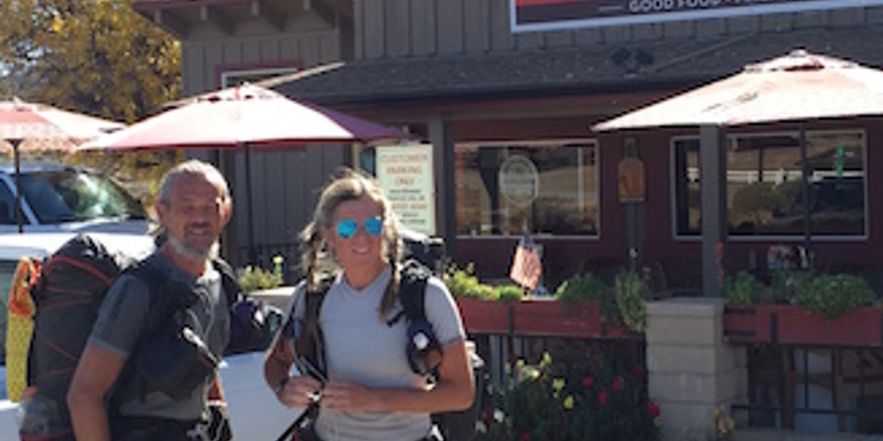
Paradise Valley Cafe
+1(951-659-3663)
at hwy.74 151.9 mi mark go west one mile
Order while on the trail, package to go>
- Come join for a wonderful meal in the mountains. Located at the intersection of the 74 and 371 highways in Mountain Center, CA, we welcome Bikers, Hikers, and Horseback riders. Our dog friendly patio is a wonderful place to spend the afternoon. So whether you are coming from the desert, the mountains, or the beach, we are here to offer you the best food in a great environment.
Open daily back to normal hours:
Sunday 8am to 3pm
Mon-Tue 8am-3pm
Wed-Sat 8am-8pm
- some nights can be closed earlier
Can get rides to Idyllwild for here by Trail Angels!
Water during opertion hours only - well water.
1 mile W of PCT of the hwy 74 crossing.
Words about - MAYOR MAX Now Mayor Max III Arriving Dec.

Mayor Max, I (the first) visited with Kirsten Garrett of Menifee, California on July 21, 2012.
Mayor Max, II, Deputy Mayor Mitzi, and Deputy Mayor Mikey with Idyllwild visitors, November, 2013
Mayor Max, II, Deputy Mayor Mitzi, and Deputy Mayor Mikey with Idyllwild visitors, November, 2013
Welcome to Mayor Max's website.
Max (Maximus Mighty-Dog Mueller) was voted into office during an election held on June 11, 12, and 13, 2012 in Idyllwild, and was inaugurated to a one-year term on July 1, 2012.
As Idyllwild is a non-incorporated town, it has no human mayor. Idyllwild Animal Rescue Friends (ARF), a non-profit 501(c)(3), spons
Welcome to Mayor Max's website.
Max (Maximus Mighty-Dog Mueller) was voted into office during an election held on June 11, 12, and 13, 2012 in Idyllwild, and was inaugurated to a one-year term on July 1, 2012.
As Idyllwild is a non-incorporated town, it has no human mayor. Idyllwild Animal Rescue Friends (ARF), a non-profit 501(c)(3), sponsored Idyllwild's first-ever mayoral election. Any local resident was permitted to nominate his or her dog or cat. 14 dogs and 2 cats were nominated and ran for office. Constituents cast their votes via $1 donations each, and all $31,000 of the proceeds benefited ARF.
Max won a full two-thirds of the votes, and became Idyllwild's first mayor.
Max's popularity moved the people of Idyllwild to appeal to ARF for his continuation in office beyond his one-year term. On February 9, 2013, ARF announced the extension of his one-year term to a second and final year, ending on June 30, 2014.
On April 2, 2013, Mayor Max passed away. The successor for the remainder of Max's term, Maximus Mighty-Dog Mueller, II, arrived in Idyllwild on July 21, 2013. Idyllwild Animal Rescue Friends approved his mayoral transition plan.
Upon his arrival to Idyllwild, Max was accompanied by two deputy mayors: Mikey and Mitzi (Mikey Mighty-Dog Mueller and Mitzi Marie Mueller). The trio is often referred to as "the Mayor and the spares" or simply "the Mayors of Idyllwild."
Mayor Max, Deputy Mayor Mikey, and Deputy Mayor Mitzi are all related to Mayor Max, I; all four dogs share a common ancestor. Mikey and Mitzi are siblings from the same litter, and Max is a cousin of theirs. Mikey and Mitzi were born in Ohio, and Max was born in California.
In March of 2014, as the June 30 end of Max's term approached, ARF solicited the town's interest in holding another election. Once again, the people overwhelmingly pled for Mayor Max's continuation in perpetuity. Mayor Max and his two deputies, Mikey and Mitzi, continue to serve the town of Idyllwild.
Feel free to contact the Office of Mayor Max of Idyllwild at any time.
Mayor Max, II, Deputy Mayor Mitzi, and Deputy Mayor Mikey with Idyllwild visitors, November, 2013
Mayor Max, II, Deputy Mayor Mitzi, and Deputy Mayor Mikey with Idyllwild visitors, November, 2013
Mayor Max, II, Deputy Mayor Mitzi, and Deputy Mayor Mikey with Idyllwild visitors, November, 2013
Job Description
The Idyllwild Mayor shall do his/her best to be a positive representative for the communities of Idyllwild, Pine Cove, Fern Valley, and Mountain Center.
The Mayor shall:
- endeavor to promote this mountain community on and off the Hill.
- support commissioners in their projects.
- strive to be present at community events suc
Job Description
The Idyllwild Mayor shall do his/her best to be a positive representative for the communities of Idyllwild, Pine Cove, Fern Valley, and Mountain Center.
The Mayor shall:
- endeavor to promote this mountain community on and off the Hill.
- support commissioners in their projects.
- strive to be present at community events such as outdoor concerts, festivals, fairs, and the July 4 parade.
- do his/her best to accept invitations for official visits, such as ribbon cuttings, "mixers," etc.
- speak out on behalf of the animals of this mountain, domesticated and non-domesticated.
Has pasted on 2022
Mayor Max III arriving soon - story at
{Idyllwild "Town Crier" Vol. 77 No. 42 Thurs. Oct, 20, 2022}
Mayor Max, III aka: Maximus Mighty-Dog Mueller, III. *******Come and see how he has grown
Mayor Max, II, Deputy Mayor Mitzi, and Deputy Mayor Mikey with Idyllwild visitors, November, 2013
Mayor Max, III aka: Maximus Mighty-Dog Mueller, III. *******Come and see how he has grown
Office of the Mayor of Idyllwild
P.O. Box 1848
Idyllwild, California 92549
+1(951) 659-0283 Mayor Headquarters Office
+1(949) 525-0100 Phyllis Mueller Mobile
On September 5, 2022, Mayor Max, III was born. He arrived home on November 6, 2022, along with his sister, Meadow. Mayor Max, III's debut to Idyllwild and
Office of the Mayor of Idyllwild
P.O. Box 1848
Idyllwild, California 92549
+1(951) 659-0283 Mayor Headquarters Office
+1(949) 525-0100 Phyllis Mueller Mobile
On September 5, 2022, Mayor Max, III was born. He arrived home on November 6, 2022, along with his sister, Meadow. Mayor Max, III's debut to Idyllwild and commencement of duties was on December 10, 2022.
Mayor Max, III continues to serve the town of Idyllwild, along with Vice Mayor Meadow, Deputy Mayor Mikey, and Deputy Mayor Mitzi.
When you come, please be sure we meet! I am in town daily, but always welcome visitors and locals to call and arrange meet-ups.